Weather Satellites
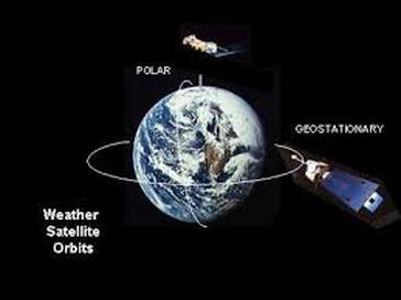
The weather satellite is a type of satellite that is primarily used to monitor the weather and climate of the Earth. Satellites can be either polar orbiting, seeing the same swath of the Earth every 12 hours, or geostationary, hovering over the same spot on Earth by orbiting over the equator while moving at the speed of the Earth's rotation.
These meteorological satellites, however, see more than clouds and cloud systems. City lights, fires, effects of pollution, auroras, sand and dust storms, snow cover, ice mapping, boundaries of ocean currents, energy flows, etc., and other types of environmental information are collected using weather satellites. Weather satellite images helped in monitoring the volcanic ash cloud from Mount St. Helens and activity from other volcanoes such as Mount Etna. Smoke from fires in the western United States such as Colorado and Utah have also been monitored.
Other environmental satellites can detect changes in the Earth's vegetation, sea state, ocean color, and ice fields. For example, the 2002 oil spill off the northwest coast of Spain was watched carefully by the European ENVISAT, which, though not a weather satellite, flies an instrument (ASAR) which can see changes in the sea surface.
The first weather satellite, Vanguard 2, was launched on February 17, 1959. It was designed to measure cloud cover and resistance, but a poor axis of rotation kept it from collecting a notable amount of useful data.
The first weather satellite to be considered a success was TIROS-1, launched by NASA on April 1, 1960. TIROS operated for 78 days and proved to be much more successful than Vanguard 2. TIROS paved the way for the Nimbus program, whose technology and findings are the heritage of most of the Earth-observing satellites NASA and NOAA have launched since then.
Types There are two basic types of meteorological satellites: geostationary and polar orbiting.
Geostationary Geostationary weather satellites orbit the Earth above the equator at altitudes of 35,880 km (22,300 miles). Because of this orbit, they remain stationary with respect to the rotating Earth and thus can record or transmit images of the entire hemisphere below continuously with their visible-light and infrared sensors. The news media use the geostationary photos in their daily weather presentation as single images or made into movie loops. These are also available on the city forecast pages of noaa.gov (example Dallas, TX).[6]
Several geostationary meteorological spacecraft are in operation. The United States has three in operation.
Polar orbiting weather satellites circle the Earth at a typical altitude of 850 km (530 miles) in a north to south (or vice versa) path, passing over the poles in their continuous flight. Polar satellites are in sun-synchronous orbits, which means they are able to observe any place on Earth and will view every location twice each day with the same general lighting conditions due to the near-constant local solar time. Polar orbiting weather satellites offer a much better resolution than their geostationary counterparts due their closeness to the Earth.
The United States has the NOAA series of polar orbiting meteorological satellites, presently NOAA 17 and NOAA 18 as primary spacecraft, NOAA 15 and NOAA 16 as secondary spacecraft, NOAA 14 in standby, and NOAA 12. Europe has the Metop-A satellite. Russia has the Meteor and RESURS series of satellites. China has FY-1D and FY-3A. India has polar orbiting satellites as well.
